
After rain, sleet and freezing rain Monday morning, precipitation has ended on Monday afternoon. Temperatures have risen to above freezing, and we'll stay above freezing for the next several hours in New Orleans & much of the Northshore.
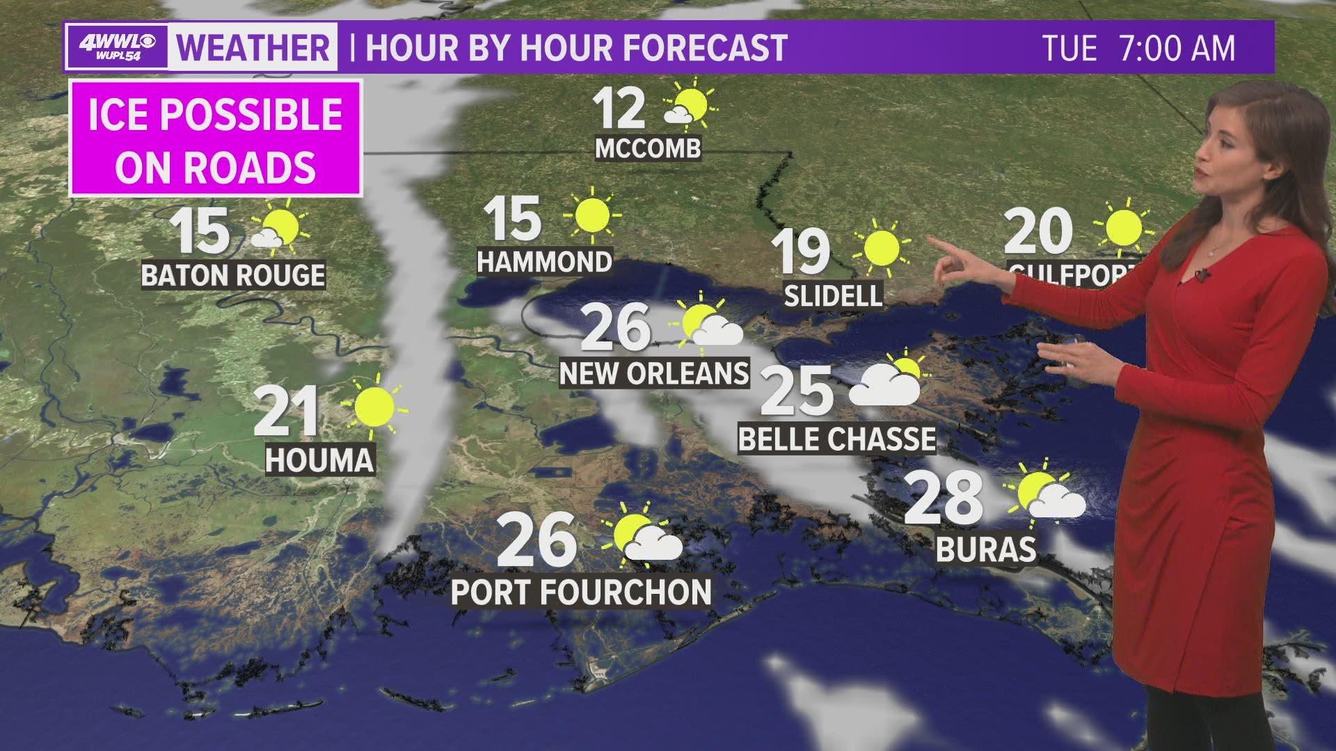
This will give roads a chance to dry out Monday afternoon. However - any water left on roads on Monday evening will freeze, which would mean spots of ice on roads Tuesday morning.
We're also expecting hard freeze conditions across our area Monday night through Tuesday morning. Protect exposed outdoor pipes, as well as plants, pets and people.
New Orleans Metro
(Orleans, Upper Jefferson, Upper St. Bernard, Upper Plaquemines)
- TIMING: Freezing weather through Tuesday 11 p.m.
- PRECIP: None.
- TRAVEL: Some slick spots could develop Monday night into Tuesday morning if any leftover moisture on roads freezes.
- TEMPS: Monday temperatures will stay in the 30s, but mid 20s are expected Monday night. Protect pipes, plants, pets and people.
St. Tammany
- TIMING: Freezing weather through Tuesday 11 p.m.
- PRECIP: None.
- TRAVEL: Some slick spots could develop Monday night into Tuesday morning if any leftover moisture on roads freezes.
- TEMPS: Monday temperatures will stay in the low 30s, but mid to upper 10s are expected Monday night. Protect pipes, plants, pets and people.
Washington Parish & Pearl River County
- TIMING: Freezing weather through Tuesday noon.
- PRECIP: None.
- TRAVEL: Some slick spots could develop Monday night into Tuesday morning if any leftover moisture on roads freezes.
- TEMPS: Monday temperatures will stay in the low 30s, but mid to upper 10s are expected Monday night. Protect pipes, plants, pets and people.
Tangipahoa
- TIMING: Freezing weather through Tuesday 3 p.m., then again Tuesday 6 p.m. to Wednesday 7 a.m.
- PRECIP: None.
- TRAVEL: Ice currently on roads will make travel dangerous through much of Tuesday. Since temperatures there may just barely rise above freezing for a few hours Tuesday afternoon, it's possible that a travel hazard could continue even into early Wednesday. Travel is not advised.
- TEMPS: Monday temperatures stay near freezing, but mid to low 10s are expected Monday night with wind chills approaching zero degrees. Protect pipes, plants, pets and people.
Lower Plaquemines & East St. Bernard
- TIMING: Freezing weather Monday 6 p.m. to Tuesday 11 a.m..
- PRECIP: None.
- TRAVEL: Roads will remain wet through the morning and afternoon.
- TEMPS: Monday temperatures will stay in the 30s to near 40, but upper 20s are expected Monday night. Protect pipes, plants, pets and people.
Lower Jefferson
- TIMING: Freezing weather through Tuesday 11 a.m.
- PRECIP: None.
- TRAVEL: Roads will remain wet through the morning and afternoon.
- TEMPS: Monday temperatures will stay in the 30s to near 40, but upper 20s are expected Monday night. Protect pipes, plants, pets and people.
Terrebonne & Lafourche
- TIMING: Freezing weather through Tuesday 11 a.m.
- PRECIP: None.
- TRAVEL: Some slick spots could develop Monday night into Tuesday morning if any leftover moisture on roads freezes.
- TEMPS: Monday temperatures will stay in the low 30s to upper 20s, but mid to upper 10s are expected Monday night. Protect pipes, plants, pets and people.
St. Charles, St. James, St. John, Assumption
- TIMING: Freezing weather through Tuesday noon..
- PRECIP: None.
- TRAVEL: Light ice accumulation could lead to dangerous travel Monday night into Tuesday. Travel is not advised.
- TEMPS: Monday temperatures will fall into the upper 20s, but mid to low 10s are expected Monday night with wind chills approaching zero degrees. Protect pipes, plants, pets and people.
Hancock and Harrison counties, MS
- TIMING: Freezing weather Monday 6 p.m. through Tuesday 10 a.m.
- PRECIP: None.
- TRAVEL: Roads will remain wet through Monday afternoon.
- TEMPS: Monday temperatures will stay in the 30s, but mid 20s are expected Monday night. Protect pipes, plants, pets and people.