
NEW ORLEANS — A storm system that left widespread damage and some injuries in its wake in Texas is drifting into Louisiana, Mississippi and Alabama.
Strong to severe thunderstorms will charge in Tuesday late afternoon and evening with a threat of damaging wind gusts, large hail and a few tornadoes.
The severe threat on Tuesday will be highest in our most northern parishes and counties, but severe storms are possible all across our area including New Orleans and coastal spots.
Louisiana’s federal and state authorities reminded thousands of hurricane survivors living in government-provided mobile homes and recreational vehicle trailers to have an evacuation plan ready as the structures might not withstand the expected weather.
Parish-By-Parish Impacts
Here is an idea of what to expect in your parish or county. Remember the exact timing could still change some.
Orleans / Upper Jefferson
- Rain timing: Roughly 5 p.m. to 8 p.m. Tuesday
- Severe risk: Enhanced (level 3 of 5 – numerous severe storms possible)
- Threats: Damaging wind gusts, tornado, large hail.
- Rainfall: 1-2"+
- Wind ahead of storms: 15-25 mph, gusts to 40 mph
Tangipahoa
- Rain timing: Roughly 2 p.m. to 7 p.m. Tuesday
- Severe risk: Moderate (level 4 of 5 – widespread severe storms likely)
- Damaging wind gusts, strong tornadoes possible, large hail.
- Rainfall: 1-3"+
- Wind ahead of storms : SE 15-25 mph, gusts to 40 mph
Washington
- Rain timing: Roughly 3 p.m. to 8 p.m. Tuesday
- Severe risk: Moderate (level 4 of 5 – widespread severe storms likely)
- Threats: Damaging wind gusts, strong tornadoes possible, large hail.
- Rainfall: 1-3"+
- Wind ahead of storms: SE 15-25 mph, gusts to 40 mph
St. Tammany
- Rain timing: Roughly 5 p.m. to 9 p.m. Tuesday
- Severe risk: Enhanced (level 3 of 5 – numerous severe storms possible)
- Threats: Damaging wind gusts, strong tornadoes possible , large hail.
- Rainfall: 1-3"+
- Wind ahead of storms: SE 15-25 mph, gusts to 40 mph
St. Charles, St. James, St. John
- Rain timing: Roughly 4 p.m. to 7 p.m. Tuesday
- Severe risk: Enhanced (level 3 of 5 – numerous severe storms possible)
- Threats: Damaging wind gusts, tornado, large hail.
- Rainfall: 1-2"+
- Wind ahead of storms: SE 15-25 mph, gusts to 40 mph
St. Bernard
- Rain timing: Roughly 6 p.m. to 10 p.m. Tuesday
- Severe risk: Enhanced (level 3 of 5 – numerous severe storms possible)
- Threats: Damaging wind gusts, tornado, large hail.
- Rainfall: 1-2"+
- Wind ahead of storms: SE 15-25 mph, gusts to 40 mph
Upper Plaquemines
- Rain timing: Roughly 6 p.m. to 8 p.m. Tuesday
- Severe risk: Enhanced (level 3 of 5 – numerous severe storms possible)
- Threats: Damaging wind gusts, tornado, large hail.
- Rainfall: 1-2"+
- Wind ahead of storms: SE 15-25 mph, gusts to 40 mph
Lower Plaquemines, lower Jefferson
- Rain timing: Roughly 6 p.m. to 10 p.m.
- Severe risk: Slight (level 2 of 5 – scattered severe storms possible)
- Threats: Damaging wind gusts, isolated tornado, large hail.
- Rainfall: 1-2"+
- Wind ahead of storms: SE 15-25 mph, gusts to 40 mph
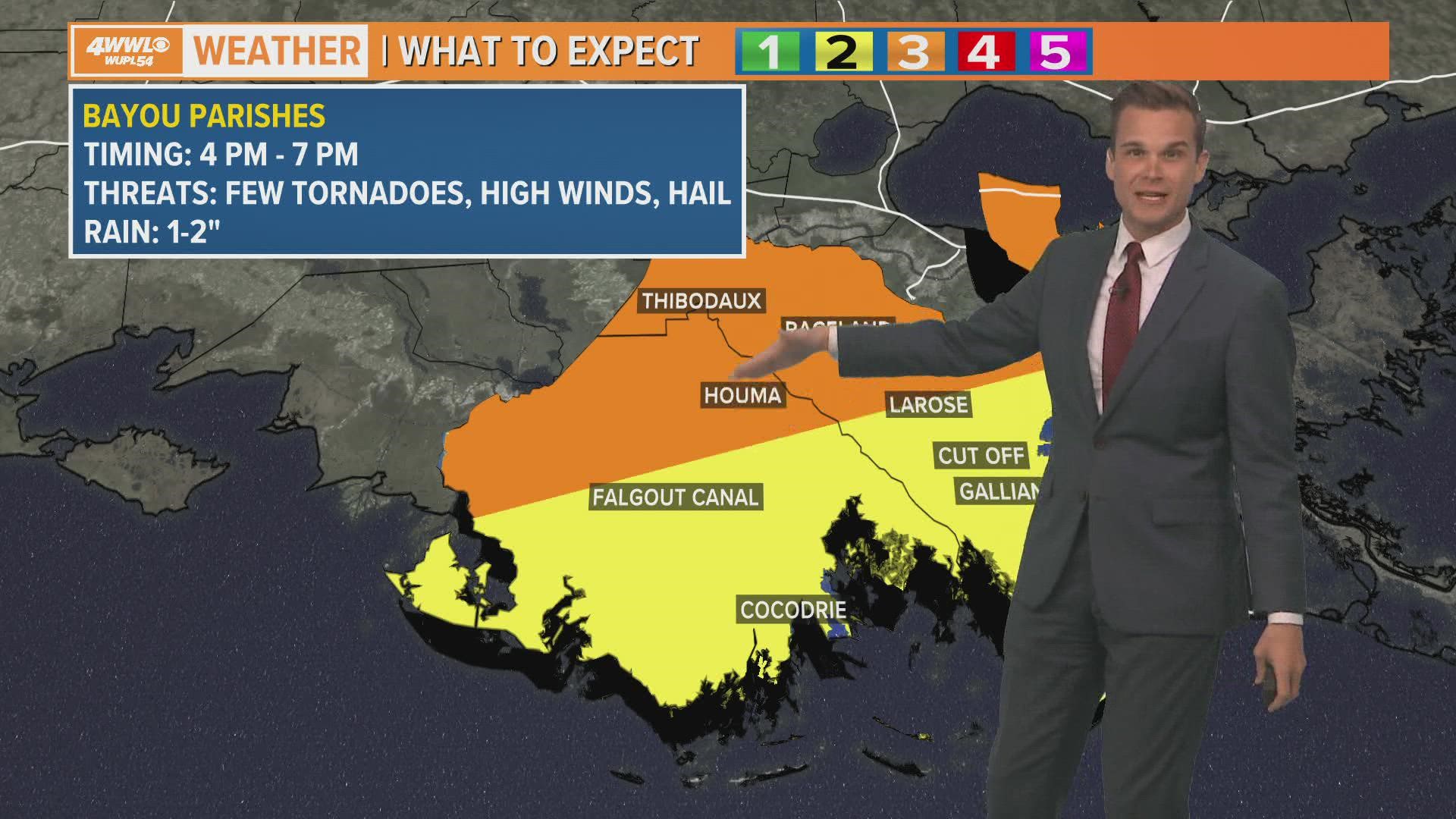
Lafourche
- Rain timing: Roughly 4 p.m. to 7 p.m. Tuesday
- Severe risk: Enhanced (level 3 of 5 – numerous severe storms possible)
- Threats: Damaging wind gusts, tornado, large hail.
- Rainfall: 1-2"+
- Wind ahead of storms: SE 15-25 mph, gusts to 40 mph
Terrebonne
- Rain timing: Roughly 4 p.m. to 7 p.m. Tuesday
- Severe risk: Enhanced (level 3 of 5 – numerous severe storms possible)
- Threats: Damaging wind gusts, tornado, large hail.
- Rainfall: 1-2"+
- Wind ahead of storms: SE 15-25 mph, gusts to 40 mph
Pearl River, MS
- Rain timing: Roughly 5 p.m. to 9 p.m. Tuesday
- Severe risk: Moderate (level 4 of 5 – widespread severe storms likely)
- Threats: Damaging wind gusts, strong tornadoes possible, large hail.
- Rainfall: 1-3"+
- Wind ahead of storms: SE 15-25 mph, gusts to 40 mph
Hancock, MS
- Rain timing: Roughly 7 p.m. to 11 p.m. Tuesday
- Severe risk: Enhanced (level 3 of 5 – numerous severe storms possible)
- Threats: Damaging wind gusts, tornado, large hail.
- Rainfall: 2-4"+
- Wind ahead of storms: SE 15-25 mph, gusts to 40 mph
► Get breaking news from your neighborhood delivered directly to you by downloading the new FREE WWL-TV News app now in the IOS App Store or Google Play.