
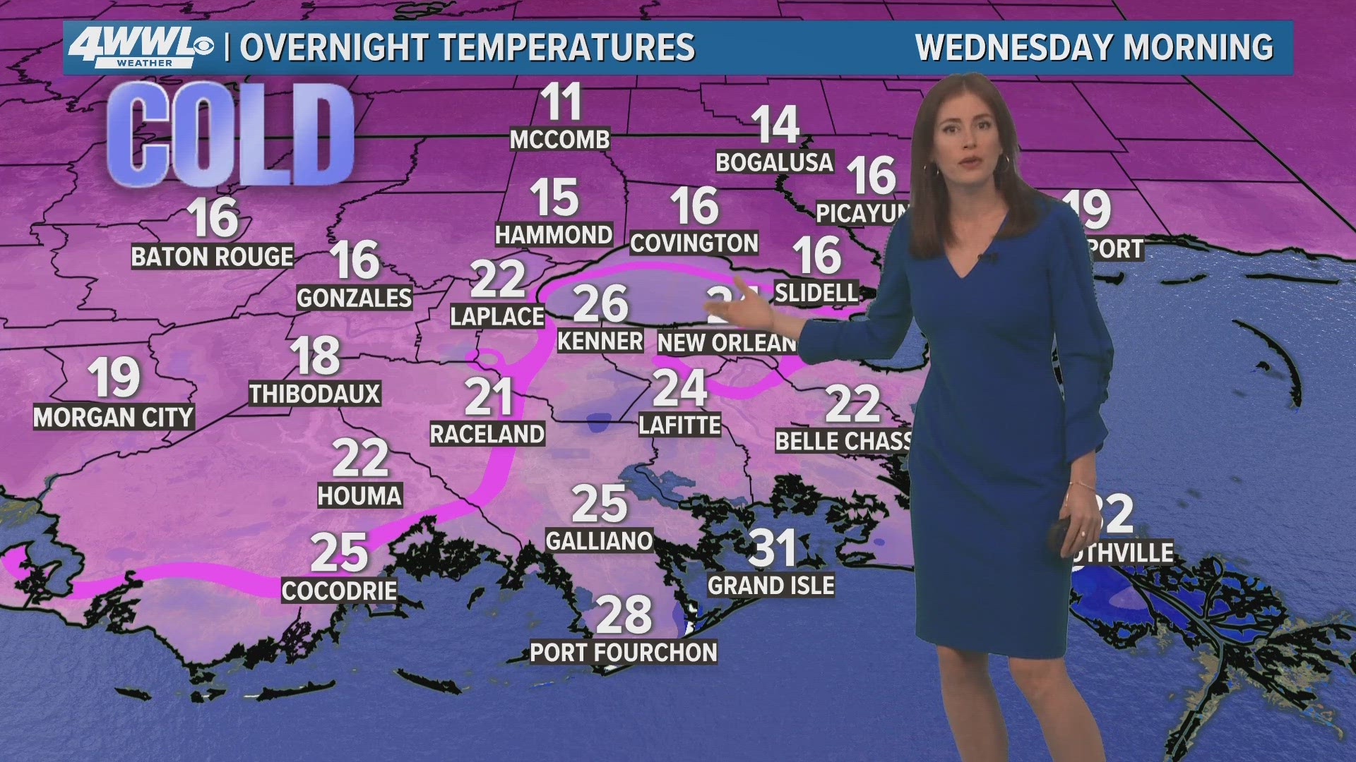
NEW ORLEANS — The main threat Tuesday night into Wednesday morning will be dangerous temperatures. Most locations will see a hard freeze Tuesday night meaning temperatures fall into the 20s long enough to cause damage to pipes if precautions are not taken. Make sure you're dripping faucets to make sure your pipes do not burst. Temperatures will climb into the 40s Wednesday afternoon.
New Orleans Metro Area
(Orleans, Upper Jefferson, Upper St. Bernard, Upper Plaquemines)
- TIMING: Tuesday into Wednesday morning.
- PRECIPITATION: No more rain or freezing precipitation is expected.
- TRAVEL: Ice melts through Tuesday afternoon and most ice is gone by Tuesday night.
- TEMPS: A hard freeze is expected Tuesday night as temperatures drop into the mid 20s. Protect people, pets, plants an pipes.
St. Tammany
- TIMING: Tuesday into Wednesday morning.
- PRECIPITATION: No more rain or freezing precipitation is expected.
- TRAVEL: Ice melts through Tuesday afternoon and most ice is gone by Tuesday night.
- TEMPS: A hard freeze is expected Tuesday night as temperatures drop into the upper teens. Protect people, pets, plants an pipes.
Washington, Pearl River County
- TIMING: Tuesday into Wednesday morning.
- PRECIPITATION: No more rain or freezing precipitation is expected.
- TRAVEL: Ice melts through Tuesday afternoon and most ice is gone by Tuesday night.
- TEMPS: A hard freeze is expected Tuesday night as temperatures drop into the mid teens. Protect people, pets, plants an pipes.
Tangipahoa
- TIMING: Tuesday into Wednesday morning.
- PRECIPITATION: No more rain or freezing precipitation is expected.
- TRAVEL: Ice melts through Tuesday afternoon and most ice is gone by Tuesday night.
- TEMPS: A hard freeze is expected Tuesday night as temperatures drop into the upper teens. Protect people, pets, plants an pipes.
Lower Plaquemines & East St. Bernard
- TIMING: Tuesday into Wednesday morning.
- PRECIPITATION: No more rain or freezing precipitation is expected.
- TRAVEL: No problems expected.
- TEMPS: A light freeze is expected for coastal areas with a hard freeze for inland spots. Protect people, pets and plants.
Lower Jefferson
- TIMING: Tuesday into Wednesday morning.
- PRECIPITATION: No more rain or freezing precipitation is expected.
- TRAVEL: No problems expected.
- TEMPS: A light freeze is expected for coastal areas with a hard freeze for inland spots. Protect people, pets and plants.
Terrebonne, Lafourche (Winter Weather Advisory)
- TIMING: Tuesday into Wednesday morning.
- PRECIPITATION: No more rain or freezing precipitation is expected.
- TRAVEL: Ice melts through Tuesday afternoon and most ice is gone by Tuesday night.
- TEMPS: A hard freeze is expected Tuesday night as temperatures drop into the low 20s. Protect people, pets, plants an pipes.
St. Charles, St. James, St. John, Assumption (Winter Weather Advisory)
- TIMING: Tuesday into Wednesday morning.
- PRECIPITATION: No more rain or freezing precipitation is expected.
- TRAVEL: Ice melts through Tuesday afternoon and most ice is gone by Tuesday night.
- TEMPS: A hard freeze is expected Tuesday night as temperatures drop into the upper teens. Protect people, pets, plants an pipes.
Hancock, Harrison counties (Winter Weather Advisory)
- TIMING: Tuesday into Wednesday morning.
- PRECIPITATION: No more rain or freezing precipitation is expected.
- TRAVEL: Ice melts through Tuesday afternoon and most ice is gone by Tuesday night.
- TEMPS: A hard freeze is expected Tuesday night as temperatures drop into the upper teens. Protect people, pets, plants an pipes.